Maryland and Virginia authorized ceding land for a future federal district.
01 — Origins
How D.C. Became the Capital
The Constitution allowed Congress to create a federal district under national control. The Residence Act of 1790 selected the Potomac region, and George Washington chose the site that became the City of Washington.
100 sq mi
Original maximum district: a 10-mile by 10-mile diamond, or 2,787,840,000 square feet.
68.34 sq mi
Modern total area after Virginia retrocession, about 1,905,209,856 square feet.
61.13 sq mi
Modern Census land area, about 1,704,206,592 square feet.
693,645
District of Columbia population estimate for July 1, 2025 from Census QuickFacts.
Timeline
The Residence Act gave President George Washington authority to locate the permanent seat of government along the Potomac.
Pierre Charles L'Enfant prepared the broad plan of diagonal avenues, ceremonial spaces, and major sites for the Capitol and President's House.
The federal government moved from Philadelphia to Washington. Congress then organized the District of Columbia under congressional authority.
The Virginia portion, including what became Arlington County and Alexandria, was returned to Virginia, reducing the district to roughly its modern footprint.
The Home Rule Act created the modern elected mayor and D.C. Council structure, while Congress retained ultimate authority over the district.
The Architectural Idea
D.C.'s public core uses the language of ancient Greece and Rome — domes, pediments, columns, axial views, and white stone — to connect the new republic with older democratic and civic symbols. L'Enfant's plan gave the city a ceremonial frame; the McMillan Plan of 1901 later reinforced the National Mall as a grand civic landscape.
02 — Architecture
Government Buildings and Styles
The capital's best-known public buildings were built over many generations. Their styles show how the federal government used classical forms, Beaux-Arts planning, and monumental scale to signal permanence.
| Building | Built / opened | Architectural style | Why it matters |
|---|---|---|---|
| U.S. Capitol | Begun in 1793; Congress first met there on Nov. 17, 1800; cast-iron dome built 1856–1866. | Neoclassical | About 1.5 million square feet, over 600 rooms, and the center of the legislative branch. |
| White House | Constructed 1792–1800; burned in 1814 and rebuilt; West Wing added in the early 1900s. | Neoclassical / Palladian influences | Designed by James Hoban and first occupied by John Adams in 1800. |
| U.S. Treasury Building | Major wings completed between 1836 and 1869. | Greek Revival / Neoclassical | A National Historic Landmark beside the White House; its west wing was completed in 1864. |
| Supreme Court Building | Completed in 1935. | Neoclassical | Cass Gilbert's marble courthouse gave the judicial branch its own monumental home. |
| Library of Congress, Thomas Jefferson Building | Opened in 1897. | Italian Renaissance / Beaux-Arts | One of the most ornate public interiors in Washington and a symbol of national learning. |
| National Archives Building | Completed in 1935. | Neoclassical | Home of the Declaration, Constitution, and Bill of Rights in the Rotunda for the Charters of Freedom. |
| Smithsonian Castle | Completed in 1855. | Norman Revival / Romanesque Revival | James Renwick Jr.'s red Seneca sandstone building became the Smithsonian's first permanent home. |
| Union Station | Opened in 1907. | Beaux-Arts | Daniel Burnham's station linked the capital to the national rail network and reinforced City Beautiful planning. |

The Capitol's west front faces the National Mall and represents D.C.'s strongest classical image of legislative government.

The Treasury Building uses a temple-like portico, long wings, and stone symmetry to project financial authority.

Historic engravings show how familiar the Treasury's colonnade became in the federal landscape.
03 — Founding Documents
The Charters of Freedom
The National Archives displays the Charters of Freedom in Washington: the Declaration of Independence, the Constitution, and the Bill of Rights. These are actual document images from National Archives downloads.
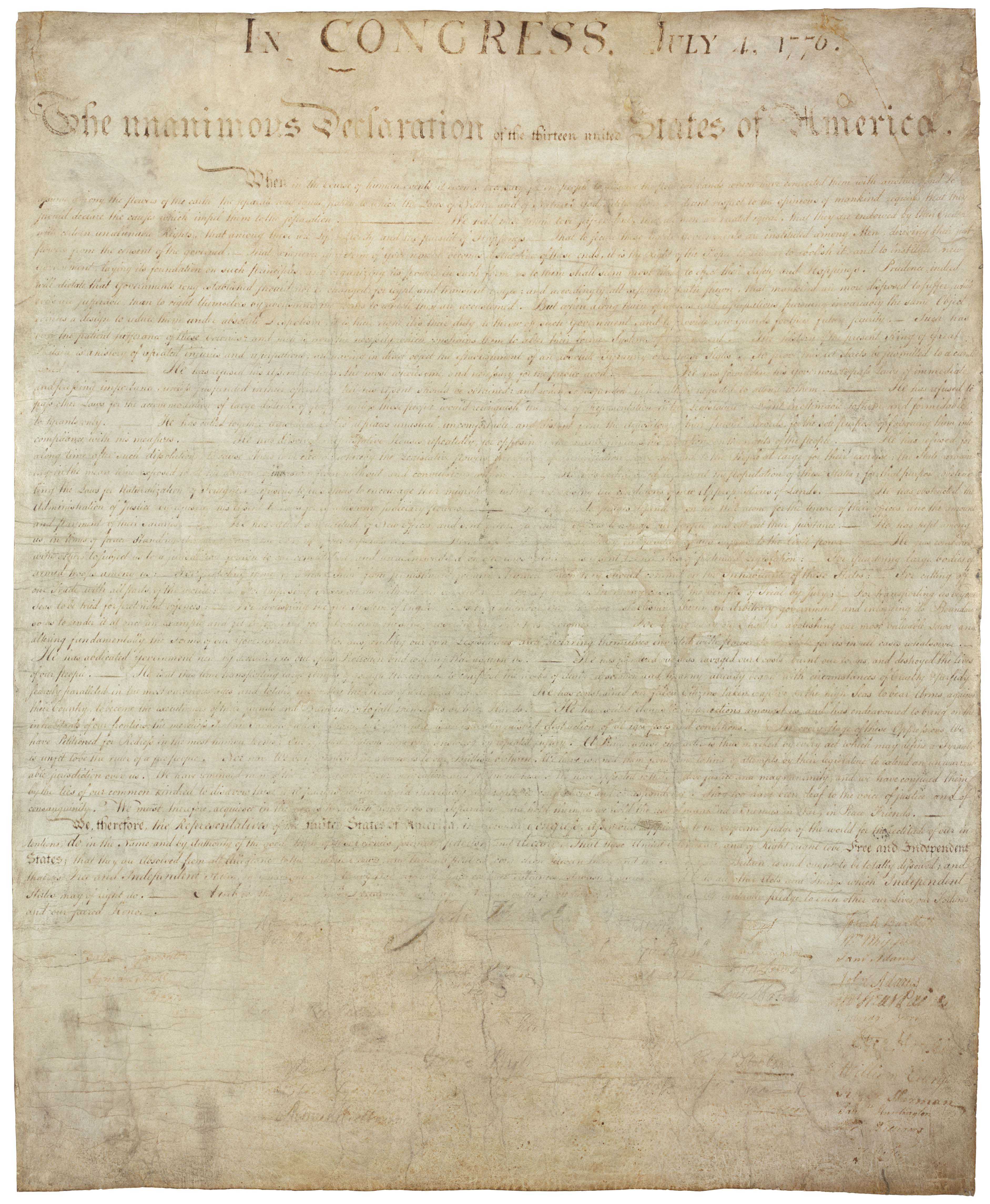
Declaration of Independence
Approved July 4, 1776. The National Archives notes that public display and age have faded the parchment.
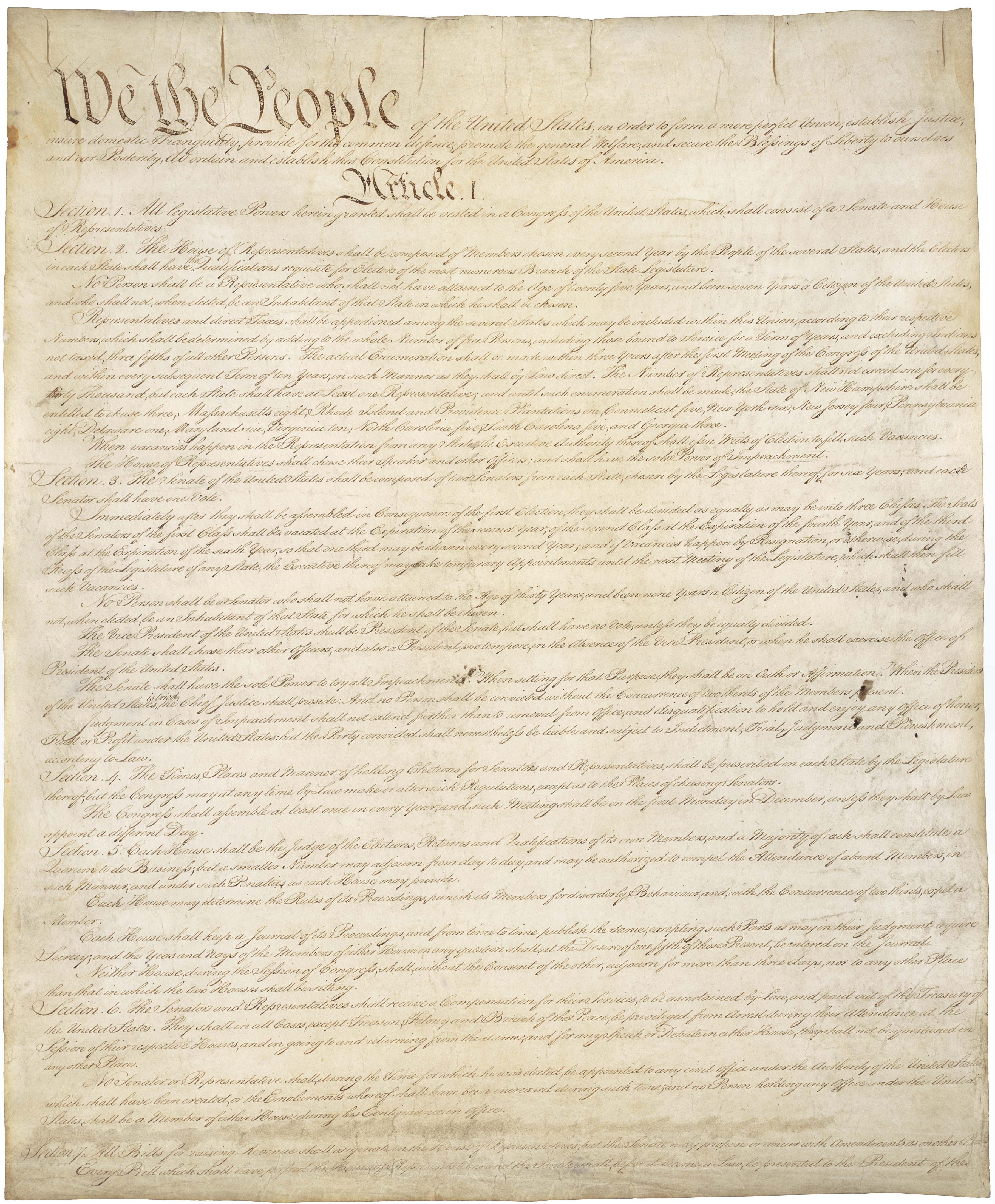
Constitution
Signed September 17, 1787. It created the federal framework that made a national district possible.

Bill of Rights
Ratified December 15, 1791. The first ten amendments limit federal power and protect civil liberties.
04 — Virtual Visits
360° Street View Stops
These links open Google Maps in panoramic Street View where available. Some federal interiors are restricted, so the Capitol card also links to the official virtual Capitol tour.
White House
Start from Pennsylvania Avenue and Lafayette Square for a 360-degree exterior view of the President's House.
Open 360° Street ViewU.S. Treasury
View the Treasury Building's long classical facade near 15th Street NW, directly east of the White House complex.
Open 360° Street ViewU.S. Capitol
Begin at the west front looking toward the dome, then use the official Capitol virtual tour for interior history.
Open 360° Street View05 — Civic Memory
Monuments and Memorials
The National Mall is a sequence of civic memory: Washington at the center line, Lincoln anchoring the west end, and the Vietnam Veterans Memorial set into the landscape nearby.
Washington Monument
Designed by Robert Mills, begun on July 4, 1848, paused for decades, completed in 1884, and opened in 1888. It is commonly given as 555 feet, 5 1/8 inches tall, and the color change partway up marks the long construction interruption.
Lincoln Memorial
Designed by Henry Bacon as a Greek Doric temple. Construction began in 1914 and the memorial was dedicated on May 30, 1922. Its 36 exterior columns represent the states in the Union when Lincoln died.
Vietnam Veterans Memorial
Dedicated on November 13, 1982, and designed by Maya Lin. The black granite wall lists service members who died or remain missing, arranged mainly by date of casualty rather than alphabetically.
Martin Luther King Jr. delivered the "I Have a Dream" speech from the Lincoln Memorial steps on August 28, 1963, giving the memorial a second life as a national civil-rights landmark.
06 — Spring Tradition
Cherry Blossoms
Washington's spring landscape is tied to a diplomatic gift. Tokyo Mayor Yukio Ozaki gave the city thousands of Japanese flowering cherry trees as a friendship gesture between Japan and the United States.
The 1912 Gift
The famous planting began after an earlier 1910 shipment had to be destroyed because of pests. A healthier 1912 shipment of 3,020 trees arrived, and First Lady Helen Taft and Viscountess Chinda planted the first two along the Tidal Basin on March 27, 1912.
Why It Became a Festival
The trees turned a diplomatic act into an annual public ritual. The National Cherry Blossom Festival now frames the Tidal Basin bloom as a celebration of renewal, tourism, and U.S.–Japan friendship.
07 — Getting There
Airport Flow
Reagan National is the closest airport to downtown D.C. Dulles is farther west and handles much of the region's international traffic. Daily figures below are annual passengers divided by 365.
~72,000/day
Reagan National, using 26.29 million passengers in 2024.
~74,000/day
Dulles, using about 27 million passengers in 2024.
1941
Washington National Airport opened; it was renamed for Ronald Reagan in 1998.
1962
Dulles opened with Eero Saarinen's modern terminal and mobile-lounge system.
For current month-by-month numbers, use the Metropolitan Washington Airports Authority traffic pages linked in the sources.
08 — Day Trips
Nearby Towns and Maps
Here are common surrounding communities for family trip planning. Population figures are 2020 Census counts for the town, city, county, or Census Designated Place named.
| Community | State / type | 2020 Census population | Map and data |
|---|---|---|---|
| Arlington | Virginia county | 238,643 | Google Map · Census QuickFacts |
| Alexandria | Virginia independent city | 159,467 | Google Map · Census QuickFacts |
| Bethesda | Maryland CDP | 68,056 | Google Map · Census QuickFacts |
| Silver Spring | Maryland CDP | 81,015 | Google Map · Census QuickFacts |
| College Park | Maryland city | 34,740 | Google Map · Census QuickFacts |
| Takoma Park | Maryland city | 17,629 | Google Map · Census QuickFacts |
| Hyattsville | Maryland city | 21,187 | Google Map · Census QuickFacts |
| Rockville | Maryland city | 67,117 | Google Map · Census QuickFacts |
| Falls Church | Virginia independent city | 14,658 | Google Map · Census QuickFacts |
09 — Bibliography
Research Sources
The page was assembled from web research, prioritizing official government, museum, and archive sources, with Wikimedia Commons for public-domain or freely licensed visual material.
Source Links
- National Archives — Declaration of Independence
- National Archives — Constitution
- National Archives — Bill of Rights
- Library of Congress — Residence Act
- White House Historical Association — Who Built the White House?
- Architect of the Capitol — U.S. Capitol Building
- U.S. Treasury — Treasury Building
- Census QuickFacts — District of Columbia
- National Park Service — Washington Monument
- National Park Service — Lincoln Memorial
- National Park Service — Vietnam Veterans Memorial
- National Park Service — Cherry Tree History
- MWAA — Reagan National Traffic Statistics
- MWAA — Dulles Traffic Statistics
- Supreme Court — Court Building
- Smithsonian — Smithsonian Institution Building
- Wikimedia Commons — National Mall at night
- Wikimedia Commons — U.S. Capitol west front
- Wikimedia Commons — Treasury Building photo